
While testing the new technique, scientists have identified perspective sand and peat extraction sites in close proximity to oil and gas infrastructure facilities in the southeast of Yamal-Nenets Autonomous Okrug.
The team of researchers included representatives from IPGG SB RAS, RN-Geology Research Development, RN-Proektirovanie Dobycha, and Kharampurneftegaz.
Practical value of the method
Construction of specialized oil and gas infrastructure facilities (transport corridors, linear facilities, and on-site structures) is a fundamental prerequisite for developing hydrocarbon deposits in permafrost regions of Western Siberia and Arctic. Using locally available industrial minerals (sand, clay, sand-gravel mixtures, and peat which are common Earth materials) is a key cost-reducing factor in such projects.
In the context of massive infrastructure facilities in the Yamal-Nenets Autonomous Okrug, the volume of required sand raw material alone can exceed 1 million cubic meters. The fact that distances from queries to construction sites may reach 300 kilometers makes transportation costs critical and can negatively impact the environment.
The development solves the problem of expensive logistics: areas promising for raw construction materials are identified directly within licensed plots of the discovered hydrocarbon fields.
Methodological novelty
The algorithm processes archival 3D seismic survey data, focusing on the upper part of the geological section with a thickness of 30 to 100 meters – this is where loose common resources —such as sand, clays, gravel, and peat —are found.
The new method utilizing neural network algorithm developed at IPGG SB RAS reprocesses archival 3D seismic data based on seismic refraction method (RWM) and multichannel analysis of surface waves (MASW), followed by attribute analysis and machine learning. The neural network is resistant to noise and does not require retraining for each new area, which favorably distinguishes it from traditional approaches.
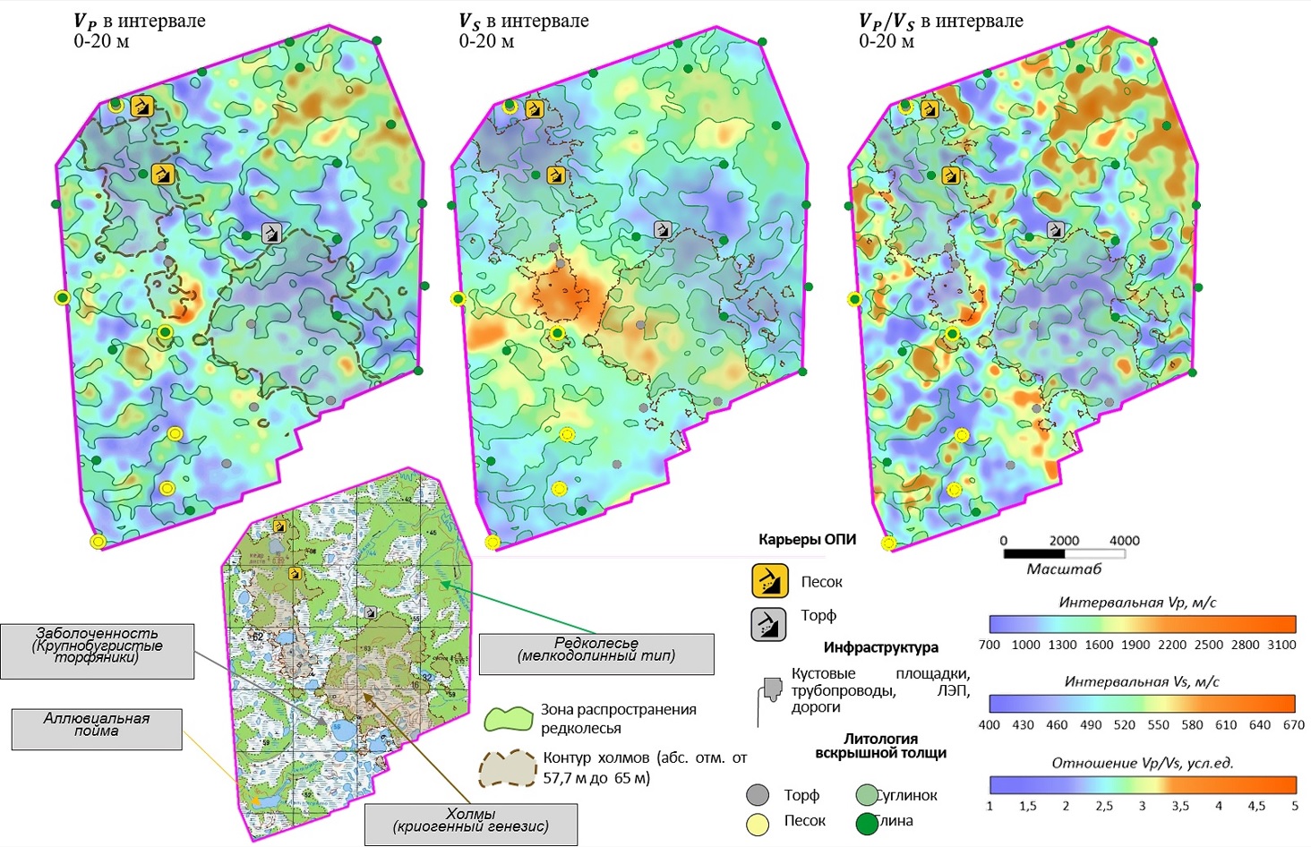
Results of the reconstructed interval velocity analysis
The new methodology provides for accurate delineation of facies with commercial resources of sand and peat, without the need for additional field measurements.
"This technology dramatically accelerates the search for common mineral resources, thus allowing launching quarry operations within just a few weeks, which is critical for delivering infrastructure engineering under tight deadlines," scientists say.
For reference
Development of the algorithm and software workflows for the MASW method was funded by the FNI (Russian National Research Foundation) project FWZZ-2026-0052.
Published by IPGG Press Service
Illustration by А.Yablokov
For more information see the article by:
A.V. Yablokov, A.V. Mamaeva, A.T. Semashev, V.D. Grishko, A.A. Kozyaev, V.V. Lukyanov, E.A. Buryak. – Predictive mapping of industrial minerals using reprocessing data by near-surface seismic methods // Russian Geology and Geophysics– 2026