
Siberian scientists have proposed a methodology for comprehensive assessment of the ecological state of post-mining areas. The analysis which is based on ten (10) criteria encompassing indicators from soil condition to radiation levels will be helpful in selecting appropriate strategies for disturbed land restoration and reclamation in Russia’s mining regions. The results of the study—supported by a grant from the Russian Science Foundation and the Novosibirsk Region Government—have been published in the Journal of Mining Institute (Zapiski Gornogo Instituta).
The mineral exploration and development activities inevitably entail disturbance of surrounding lands that may result in alterations to landscape, topsoil degradation, and eradication of vegetation. Furthermore, mining operations are often responsible for soil contamination with heavy metals and other hazardous elements.
Restoration of such areas, i.e. making them suitable for agriculture, is a complex challenge which requires both understanding of the intensity and extent of land degradation and taking area-specific remediation measures. However, there have been hitherto no tools available to comprehensively assess the environmental harm caused by the extraction of solid minerals.
Researchers from the Novosibirsk representing Chinakal Institute of Mining SB RAS, Trofimuk Institute of Petroleum Geology and Geophysics SB RAS, and Siberian State University of Geosystems and Technologies, in collaboration with colleagues from the Institute for Water and Environmental Problems (Siberian Branch of the Russian Academy of Sciences, Barnaul), have proposed an integrated approach for assessing current environmental condition in mining -disturbed areas. The approach is based on ten distinct criteria taking into account contents of hazardous and extra hazardous elements in the investigated lands, quantity of radionuclides in the water, radioactivity of country rocks, anthropogenic load on water bodies and watercourses in the vicinity of mining facilities, specific climatic conditions, availability of areas with special protection status or by-gone ecological damage, the type of impact (specifying which anthropogenic activities are responsible), etc.
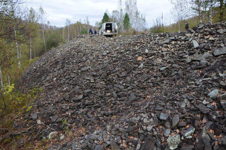
Repercussions of gold mining activities on the Suenga River
"Previous approaches to assessing mining-disturbed land traditionally focused on a single parameter—such as the content of a specific contaminant. However, mining operations have complicated repercussions on the local surroundings. Heaps of mine tailings, low-grade or unwanted minerals (gangue), and barren rock (waste rock) susceptible to weathering have the potential for releasing toxic elements, thereby causing secondary pollution. Another disamenity comes from river channel relocation, or diversion of a river channel around the mine area into an entirely new engineered channel to facilitate access to mineral deposits, which will fundamentally alter the aquatic ecosystem, hydrological regime, channel dynamics, etc. Primary changes to the channel dimensions and materials, alongside changes to flow velocity or channel capacity, can lead to a consistent set of problems such as enhanced erosion or deposition, vegetation loss, water quality issues, and associated ecological impacts reflected in aquatic biota response to habitat changes. Furthermore, the exposure of radioactive rock during mining can increase regional radioactivity background levels. To keep the situation under control, we have proposed a unified assessment system integrating these disparate data into one comprehensive overview," explains Alexander Reznik, PhD (Tech.), a senior researcher at the Chinakal Institute of Mining SB RAS.
Using this new tool, researchers assessed 106 sites in the Novosibirsk Region affected by mining activities or by underground storage of extracted minerals. The analysis revealed that, in terms of the degree of disturbance, 10% of the sites were classified as 'undisturbed' (consisting of flooded or naturally revegetated post- mining land areas), 63% as 'slightly disturbed,' 12% as 'moderately disturbed,' and 15% ‘as extremely disturbed.'
For instance, some of the sites categorized as 'disturbed land' exhibited contents of pollutants in the water or soil in excess of MAC values (maximum allowable concentrations). It is telling that a site with diverted river channel and ensuing crisis in the aquatic ecosystem was also included therein, despite the water technically met sanitary standards. This demonstrates that evaluating a site based on a single indicator may fail to reflect the true intensity and extent of the environmental damage.
Based on the collected data and using the proposed criteria, a matrix of mining -disturbed land areas was created for their further ranking by the level of their impact. The matrix which includes the objects, their environmental impact, and the adjacent area condition, allows identifying land areas ready for resuming agricultural activities, and those requiring further reclamation measures.
"Looking forward, we plan to develop recommendations for low-impact resource extraction and sustainable development of these territories. These will include land restoration measures—ranging from site-grading design and slope stabilization to the topsoil remediation and building recreational spaces. As such, the approach allows recuperating degraded lands bringing them back to life as object of economic turnover," concludes Alexander Reznik.
Source: "Science in Siberia" (Nauka v Sibiri), based on materials from the Russian Science Foundation (RSF) press service ( https://www.sbras.info/news/razrabotan-kompleksnyy-podkhod-ocenki-sostoyaniya-zemel-posle-dobychi-poleznykh-iskopaemykh)
Photo courtesy of N. A. Nemova (Institute of Mining SB RAS)
For reference:
This work was funded by the Russian Science Foundation grant (Project No. 23-27-10057) and the Novosibirsk Region grant (No. р-60).
For more details on the study, see the article by:Reznik A.V., Nemova N.A., Novikov D.A., Zarubina E.Yu., Gavrilov V.L., Kolesnikov A.A., Kosarev N.S. An approach to integrated assessment of mining-disturbed land. Journal of Mining Institute. 2026, Vol. 281. Iss. 1, p. 5-22.