Olga Toropova’s master's thesis which included implementation of the newly developed multi-layer architecture for geospatial data visualization was prepared under supervision of Vladimir Lapkovsky, Dr. Sci. (geol.-mineral.), Professor at the Faculty of Applied Mathematics and Computer Science, Novosibirsk State Technical University, and head of the Laboratory of mathematical modeling of natural petroleum systems at IPGG SB RAS.
This collaboration resulted in introducing a software for geospatial data visualization in webGIS.
As IPGG specialists explained, this software developed using a client-service architecture imposes minimal system requirements on computer equipment (its interface allows using it anywhere there is an internet connection available). The service is integrated into the KRATON, a cross-platform software for geological and geophysical analysis developed at NSU and funded under the Priority 2030 program. Its high functionality is perfectly demonstrated in its base module, the W-SEIS software developed at IPGG SB RAS, designed to interpret 2D/3D seismic and drilling data. The web interface allows visualizing both project data W-SEIS databases.
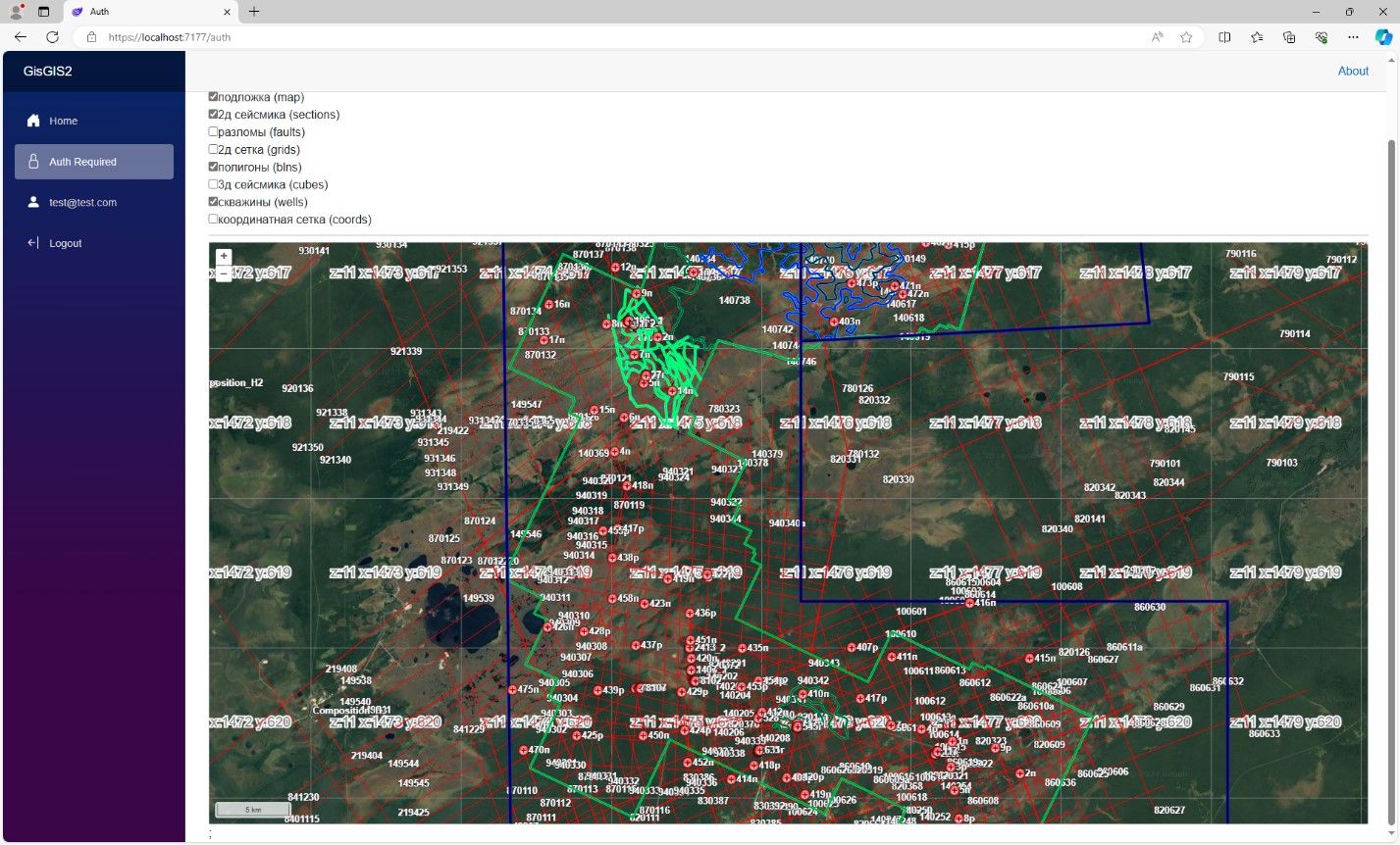
Run screen of geospatial data visualization
The advantages of the tool include its capability of easily adapting to changes in the basemap (layer containing background geographic information). The developed architecture includes many layer display options that are used to portray polygons, well positions, maps of surface geology, faults, 2D and 3D seismic profiles and cubes.
Researchers from IPGG SB RAS have appreciated the convenience and functionality of the software solution proposed by O.S. Toropova. The system she developed has passed the implementation procedure to be further used at the Institute.
Illustration courtesy of M.S. Kanakov
Published by IPGG Press Service
Novel technology developed by Novosibirsk scientists will assist in searches for oil and gas in carbonate reservoirs
Neural network algorithms developed by Russian scientists can be used for intelligent identification of nearby deposits of common geological materials
Paleontologists discovered a new species of fossil mollusk in the northern East Siberia.
V.N. Glinskikh: Operational control over the Samoylov Island research station is passing to Yakut Science Center
Deep seismic investigations of the Siberian Craton basement will help in the search for various mineral deposits in Yakutia
IPGG’s specialists in resource and energy economics presented their research findings at a conference in Irkutsk
Scientists view mudstone caprocks (seals) as primary geological indicators of hydrocarbon accumulations in the Mesozoic sedimentary cover of Vilyui Basin (Sakha Republic)
Scientists from Russia and China discussed early life on Earth spanning the Late Ordovician – Early Silurian period, with concomitant changes
A scientist from Nanjing visiting Novosibirsk within the frames of scientific collaboration between the Russian and Chinese research institutes
Technogenic deposits: a conversion from environmental threat to strategic raw materials source
Substances identified in hot springs in the Baikal area will help implement ecological monitoring of groundwaters and promote medical tourism
Russian scientists have studied the isotopic composition of natural waters in Tyumen and its surroundings.
A specialist from Novosibirsk shared his experience with colleagues from Moscow and St Petersburg
The Ninth Saks Readings launched in Akademgorodok, Novosibirsk
Scientists discussed significance of modeling the formation of large epicontinental sedimentary basins
Specialists spotlight promising oil and gas fields in Transbaikalia
Specialists have proposed a novel fiber-optic cable installation technique for seismic monitoring
New advanced developments of IPGG SB RAS specialists for testing tunnel lining and road surface integrity
Specialists from IPGG SB RAS Participate in the 72nd Session of the Paleontological Society
The idea of establishing Interdisciplinary Geophysical Research Center in Novosibirsk discussed at IPGG SB RAS
Specialists Perfecting Soil Fertility Evaluation Technique during Winter
High-resolution import-substituting regional geomagnetic models developed in Russia for oil and gas fields
Tomsk Scientists Investigate Petroleum Hydrocarbon Pollution in Siberian Soils and Waters
A specialist from Azerbaijan spoke at a geophysical seminar at IPGG SB RAS
Expeditions, Research, Educational Programs: Russia and China Launch a New Phase of Scientific Cooperation
Russia and China Will Deepen Scientific Cooperation
Scientists acknowledge Transbaikalia’s fossil sites as a treasure trove for future discoveries
The Story of Researchers about the Russian Expedition to the North and Central Atlantic
Numerical Modeling of Rock Mass Deformation and Failure Processes: an Example of Collaborative Engagement
A new oil and gas discovery named in honor of Alexey E. Kontorovich
Researchers from across Russia participate in a commemorative conference held in Akademgorodok, Novosibirsk
Nature lending a helping hand: application of fossil insects for revising ages of sedimentary rocks in Transbaikalia
Researchers from IPGG SB RAS discussed geoelectric structure of ore-bearing zones localized in Kuznetsk Alatau and Salair
Contribution of scientists from IPGG SB RAS to the discussion of fossil plant research at a major conference in Moscow
Russian scientists develop advanced algorithms for prospecting hydrocarbon deposits
Specialists from IPGG SB RAS measured radon levels in groundwaters used for public drinking water supplies in the Novosibirsk Region
'This is a unique platform': young scientists from IPGG SB RAS participated in the 5th Congress of Young Scientists
IPGG SB RAS strengthens cooperation with the Nanjing Institute of Geology and Paleontology (China)
Hydrological aspects of Transbaikalia discussed in Uzbekistan
The research focus on the Paleozoic (“old life”) era
Anomalies and more: An increasing interest in IPGG SB RAS research works from scientists around the world
Honoring the memory of the Master… A.E. Kontorovich will always be in our hearts
A cooperation agreement signed between IPGG SB RAS and Peking University (China)
IPGG’s experience in using direct surface geochemical methods in soils and snow cover for hydrocarbon prospecting
The research focused on quantification of residual hydrocarbon resources in the West Siberian Super Basin
Scientists from IPGG SB RAS visited China to participate in a large international conference
Scientists have evaluated the suitability of groundwaters as sources of drinking water in the Arctic permafrost regions of Russia
Novel methods for numerical modeling of physical processes in geophysical applications are being developed IPGG SB RAS
Boreal ammonoid fauna: scientists from IPGG SB RAS study geographical distributions of ammonoids that lived about 240 million years ago in marine basins of the Northern Hemisphere
Uzon volcano caldera: scientists go for the world's youngest oil